


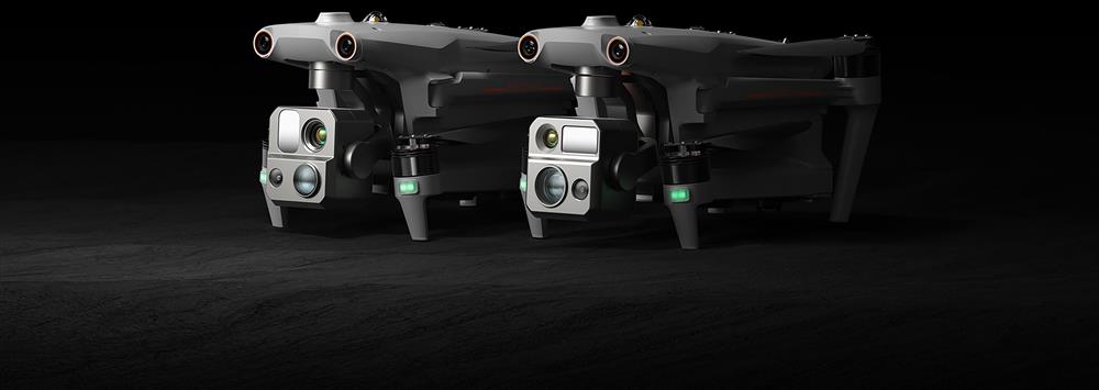
AUTEL EVO MAX 4T
Special Defense Version
- Strong anti-inteference
- No need for activation when first time powering on
- Manual FCC/CE switch
- No limits in the frequency channel
- No No-fly-zone
- Image transmission can be switched off
- AI weapon recognition
Features
- 50MP Zoom Camera or 0.0001 LUX Starlight Camera
- 640×512 Thermal Resolution
- Hot-Swappable Batteries
- IP43 Weather Rating
- 42 min Max. Flight Time
- 12.4 Miles Transmission Range
- 13,124 ft Service Ceiling
- 27 mph Max. Wind Resistance
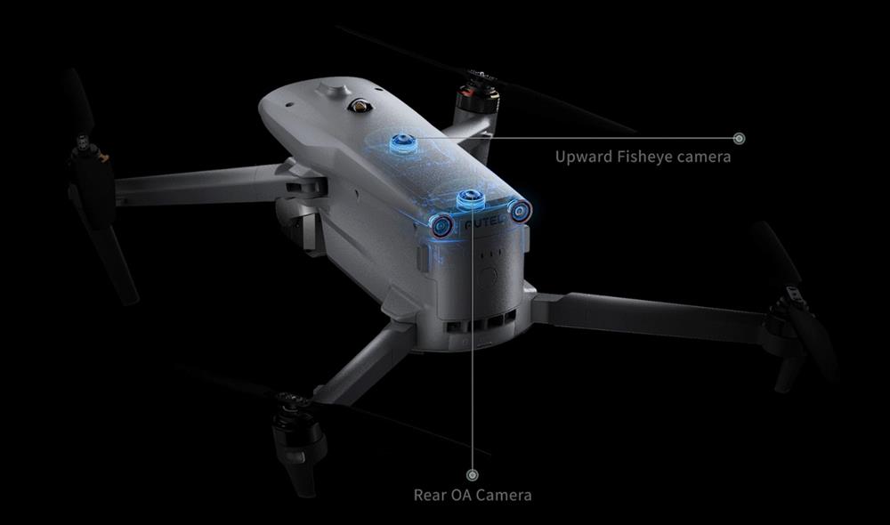
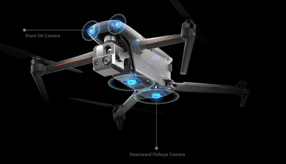
- 720° Obstacle Avoidance
Auto Path Finding
Autel's Autonomy Engine collects surrounding environmental data and plans 3D flight paths through complex environments such as mountains, forests, and buildings. Use cases include rapid 3D scene reconstruction, public safety overwatch, industrial inspection, and land surveying.
Navigation in GPS Denied Environment
Advanced sensors allow the EVO Max series to navigate within hardened structures, underground, or in environments without GPS.
Accurate Object Identification and Tracking
Based on Autel's AI recognition technology, the EVO Max series can automatically identify and lock onto different types of targets such as heat sources, moving people, or vehicles and achieve high-altitude tracking and data collection for law enforcement.
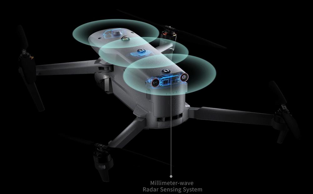
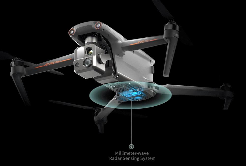
No Blind Spots
The EVO Max series is the only commercial drone that combines traditional binocular vision systems with millimeter wave radar technology. This allows the onboard Autel Autonomy Engine to perceive objects down to 0.5 inches, eliminating blind spots and enabling operation in low light or rainy conditions.
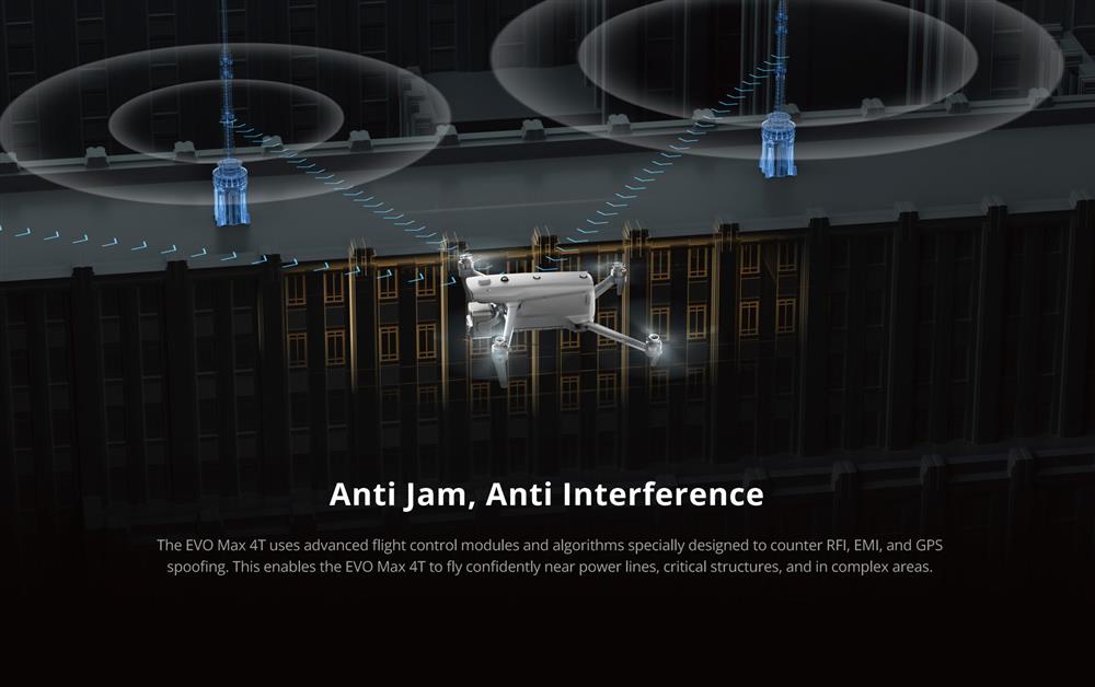
Anti Jam, Anti Interference
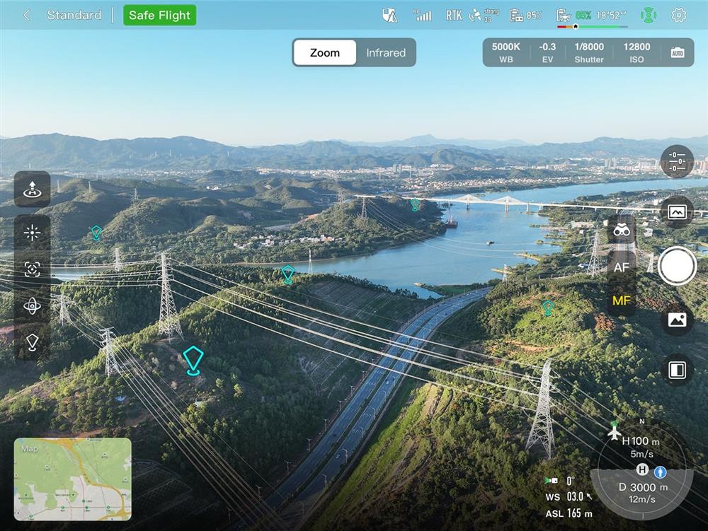
The EVO Max series uses advanced flight control modules and algorithms specially designed to counter RFI, EMI, and GPS spoofing. This enables the EVO Max series to fly confidently near power lines, critical structures, and in complex areas.
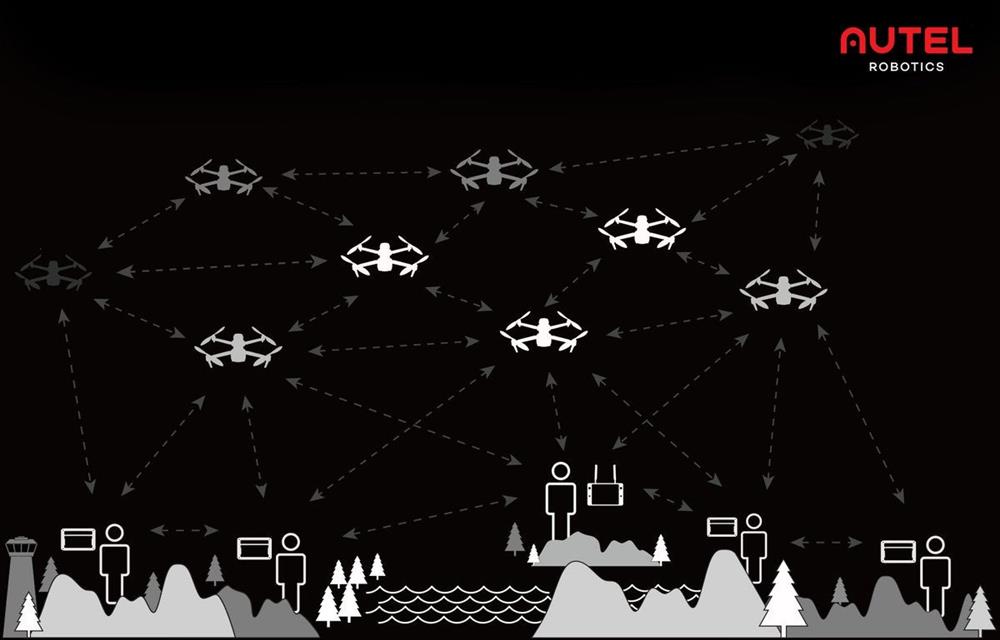
A-Mesh 1.0
The Industry's First Mesh Networking
EVO Max series features the new A-Mesh system, enabling drone-to-drone autonomous communication, connection, and collaboration.
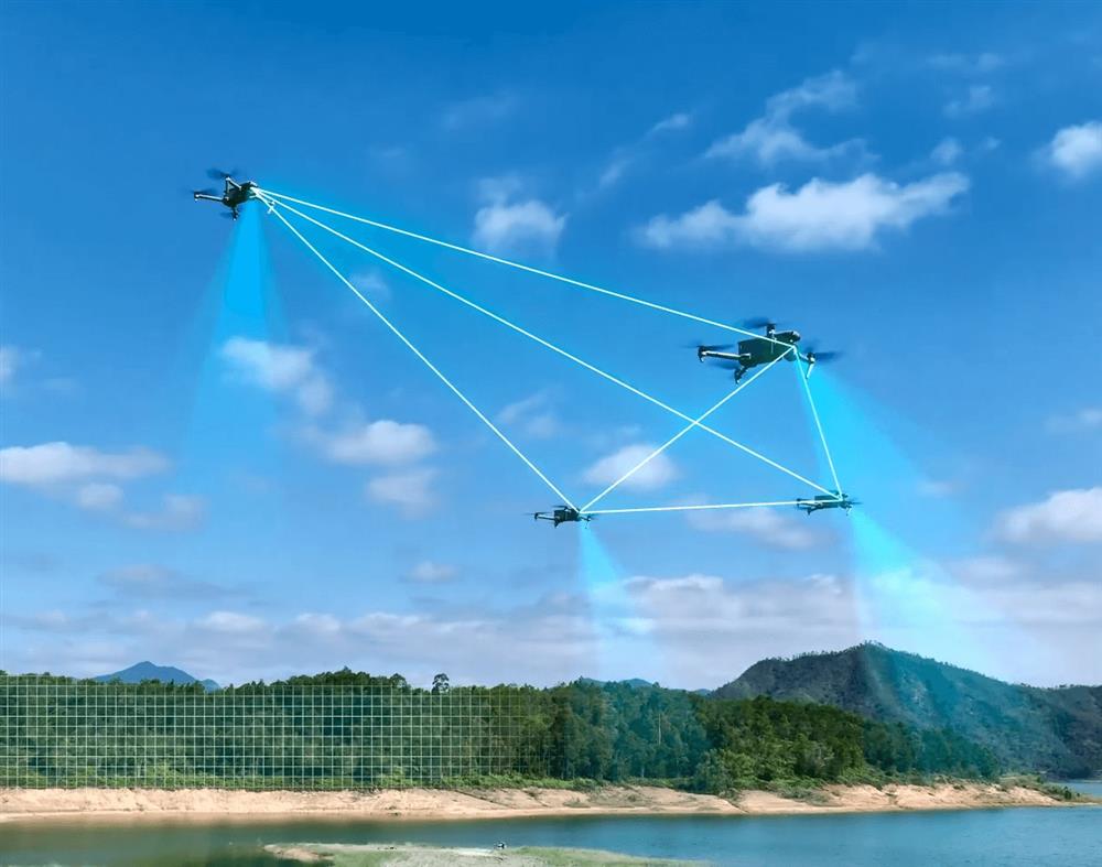
Enhanced Range
Communication nodes can be placed statically on hills or poles to provide full coverage to an area, or a swarm of drones can provide mobile communication points to extend the coverage of the entire group.
Beyond-Line-of-Sight Applications
With A-Mesh, multiple drones in the vicinity can act as relay points to greatly improve BVLOS operation effectiveness.
Enhanced Anti-Interference
The EVO Max series can communicate seamlessly with other drones in the vicinity, unlike a traditional chain structure. If a single drone fails or exits unexpectedly, the entire system will independently self-organize and continue to relay critical information.
Full-Fleet Control
Multiple drones can be controlled autonomously by 1 pilot or by a group of pilots simultaneously with or without LTE coverage.
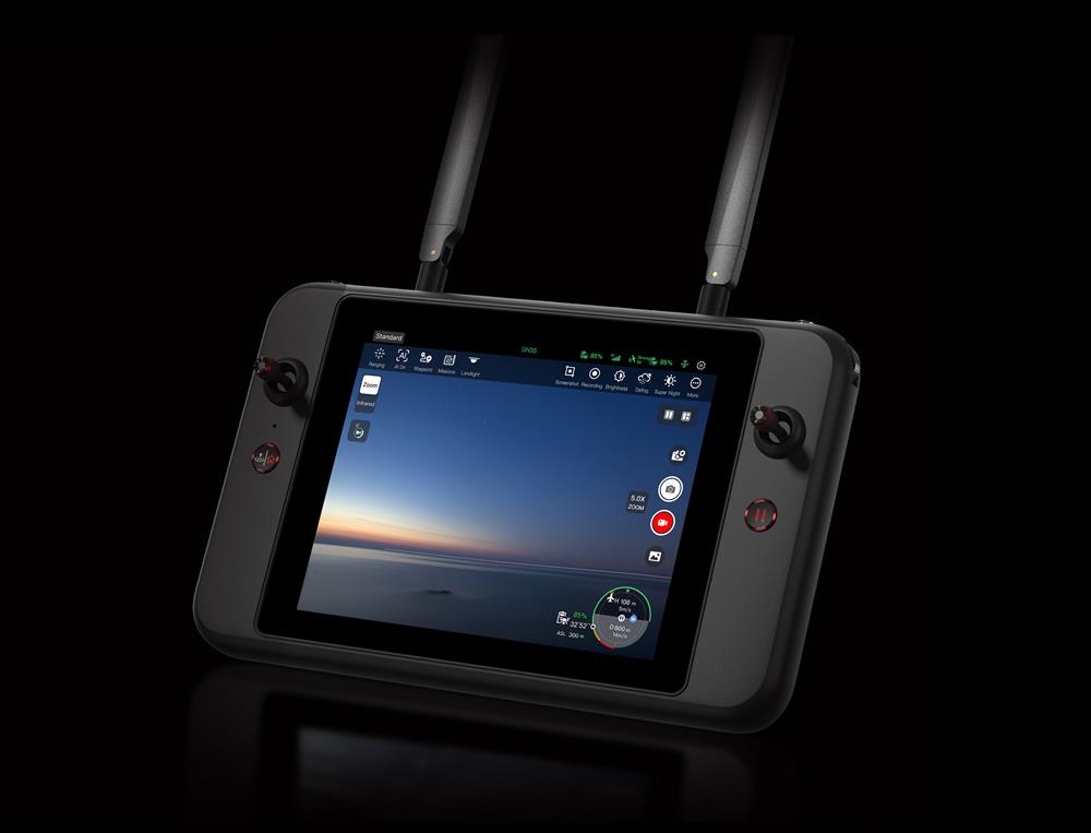
Autel SkyLink 3.0
SkyLink 3.0 system of The EVO Max Series comes with 6 antennas, 4 frequency bands, AES-256 encryption, and optional 4G integration to provide users with the most advanced flight capabilities ever in an EVO.
-
12.4 miles Image Transmission Distance
-
<150ms Latency
-
1080P@60FPS Real-Time Image Quality
- 900MHz/2.4GHz /5.2GHz/5.8GHz Frequency Bands
Mission Ready Payload
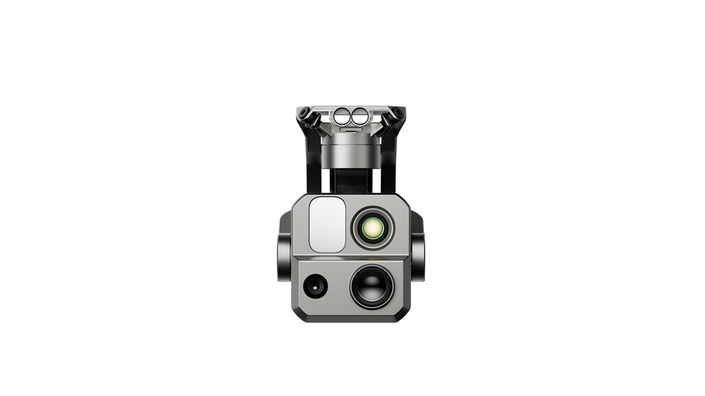
The payload integrates starlight camera, wide-angle camera, zoom camera, thermal camera,and a laser rangefinder for all data capture needs and critical decision making.
EVO Max 4T
- Zoom Camera
48MP
8K 10x Optical Zoom
160x Max. Hybrid Zoom
Aperture: f/2.8–f/4.8 - Wide Camera
50MP
1/1.28" CMOS
Aperture: f/1.9
DFVO: 85°
Equivalent: 23 mm - Thermal Camera
640×512
Aperture: 13 mm
16x Digital Zoom
Range: -20 °C to 550 °C - Laser Rangefinder
Measuring Range: 5 – 1140 m
Measurement Accuracy: ± (1 m + D×0.15%)
Chase the Heat and Explore the Night
- Starlight Camera (4N)
- Super Zoom (4T)
- Supersensitivity
- Strong Infrared Perception
- Accurate Ranging
Autel Enterprise App Platform
The Autel Enterprise App is built from the ground up for industrial applications and features a brand-new interface for simple, efficient operation. Additional features and semi-autonomous modes maximize the EVO Max series' mission capability.
Smart Features
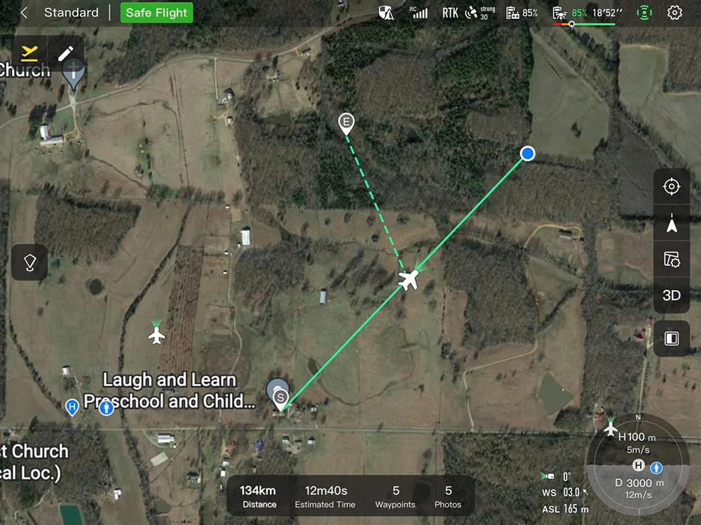
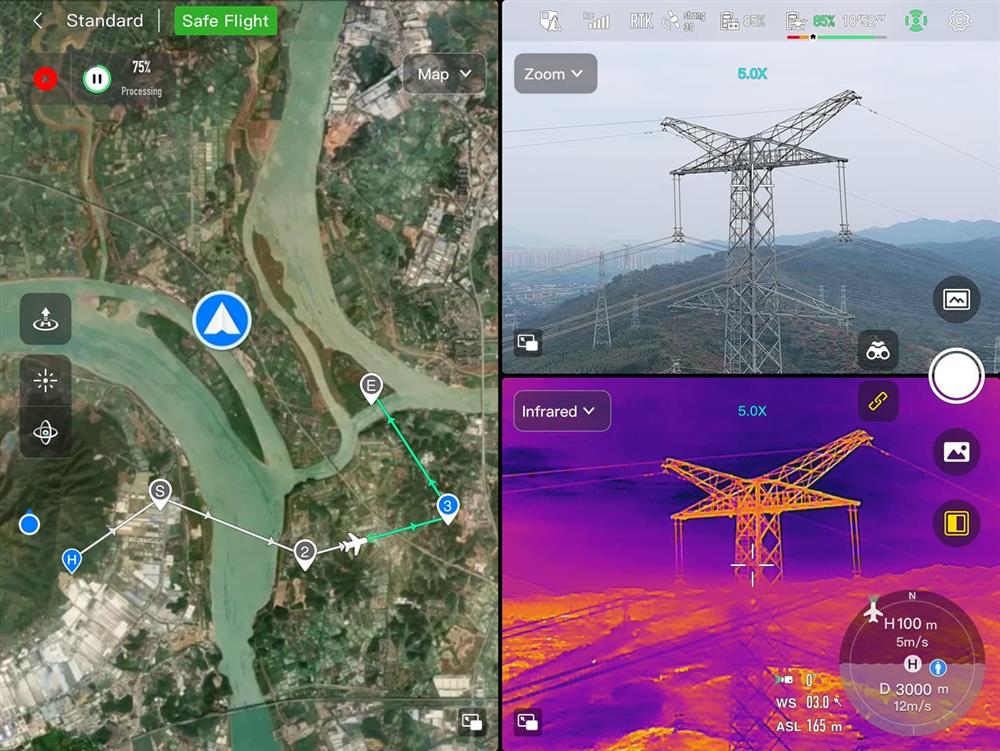
- 3D Map Planning
Plan, create, and execute 3D waypoint missions on a 3D map, and switch map sources as required.
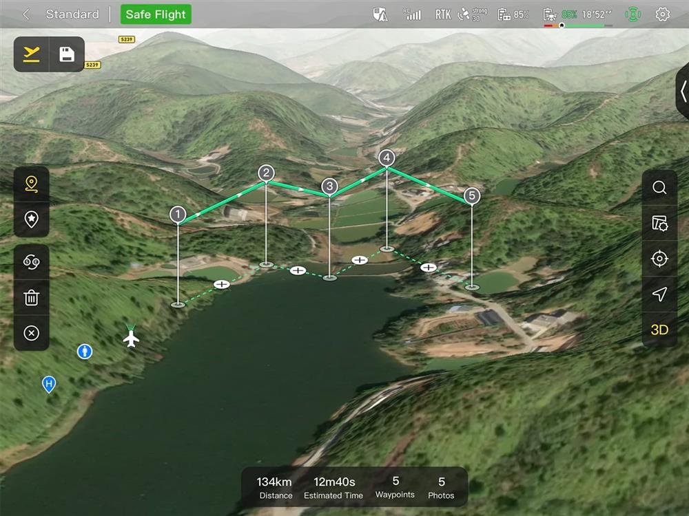
- Quick Mission
Temporary missions can be created while executing other missions, and multiple sub-missions can be stacked for enhanced flexibility.
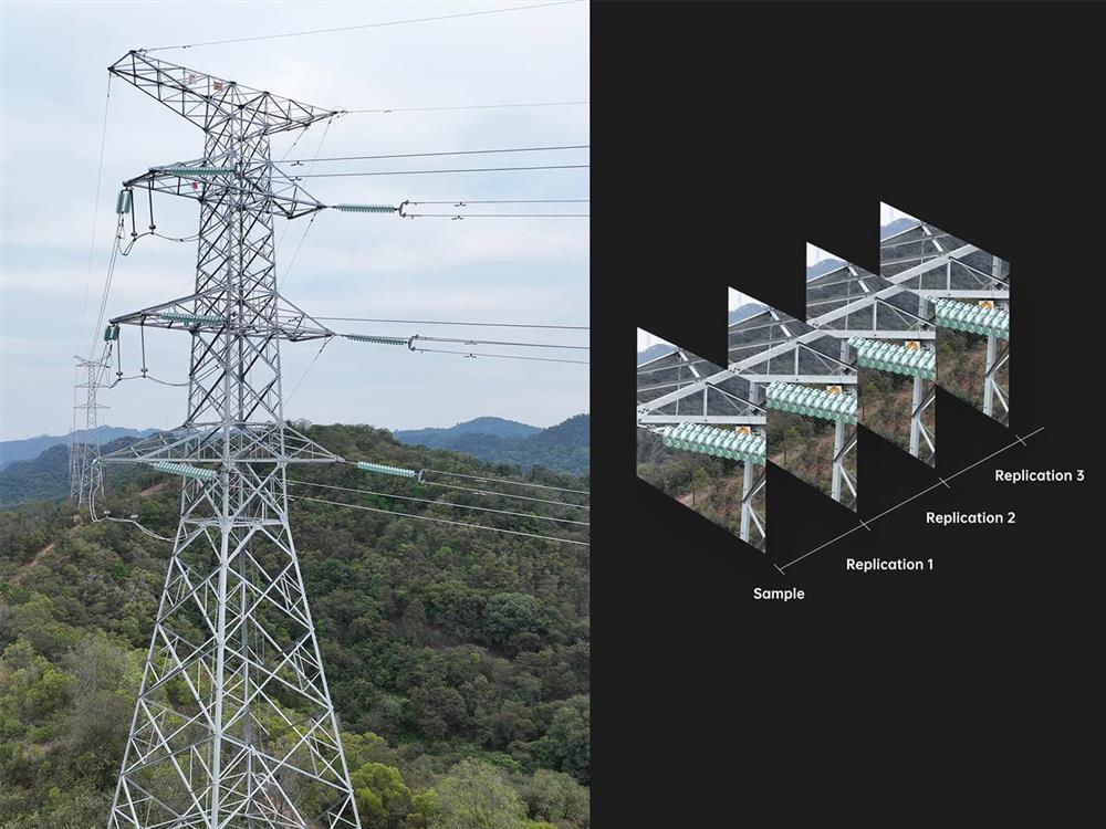
- Mission Reproduction
The EVO Max series automatically records the camera angles and replicates the mission you just flew.
Multiple Mission Types
The Enterprise App provides various autonomous and semi autonomous mission planning for public safety, inspection, and surveying.
- Vertical Scan
Perform vertical surveys for building facades,
open pit walls, and towers.
- Corridor Mission
Supports intuitive and effective corridor mission planning for roads, rivers, pipelines, power lines and other narrow,large-scale terrain.
- Polygon Mission
Supports one-click automatic generation of polygon flight areas.
- Terrain Follow
Maintain relatively constant altitude from the
ground for uneven or sloped terrain.
- Rectangular Mission
Supports one-click automatic generation of
a rectangular flight area.
- Automatic Mission Generation And Data Capture
Automatically produce routes by adding regional boundary
points through dots or importing KML files.
- Waypoint Missions
Users can add waypointsfor flexible, non-structured flight paths.
- Oblique Photography
Automatically plan 5 groups of routes (1 ortho + 4 oblique)
according to the flight area set by the user.
- Spiral Mission
Supports helical flight search in a designated area for SAR.
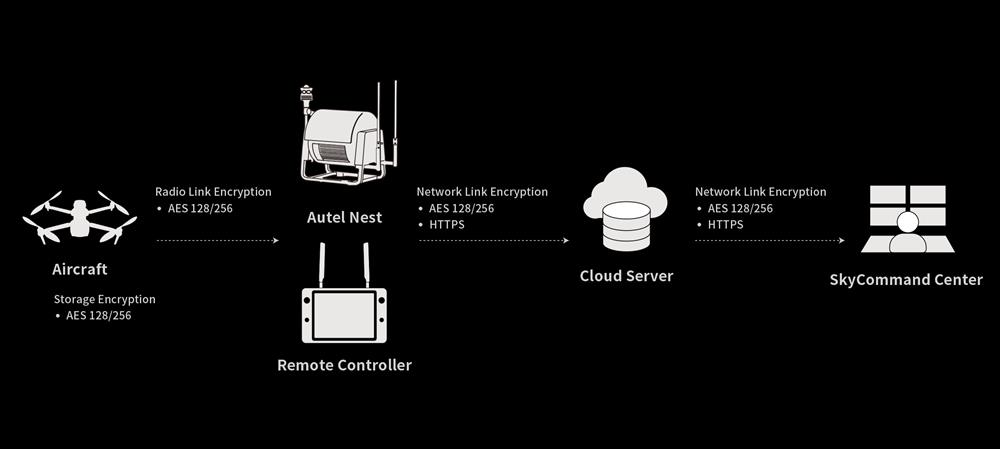
Data Security
Data* can only be physically accessed via the aircraft locally, and can be encrypted using AES-256 and passwords.
*User and aircraft information, including flight logs, locations, and accounts.
Enhanced Live-View
Multi-channel Projection Screen
Supports simultaneous output of RGB/night vision, infrared, and Map.
AR Scene
Geo-location data and other aircraft location info detected by ADS-B can overlay on real-time map, which is convenient for you to confirm the drone's location and avoid airborne risks.
Operating Environment
-
IP43 Rating
-
-4 ? to 122 ? Temperature

Complete Remote Operations System
Used with the EVO Nest, the EVO Max series supports all-weather auto piloting for scenarios such as substations, industrial parks, and rooftops.
Autel SDK
The Autel SDK is open to the world, helping developers and partners reduce software and hardware development costs and jointly create a new industry ecosystem.
-
Mobile SDK
Open UX SDK (iOS/Android) can directly call up the ready-made interactive interface.
Application
-
Public Safety
-
Search & Rescue
-
Inspection
- Firefighting
| Основне | |
| Тип: | квадрокоптер |
| Швидкість підйому: | 8 м/с |
| Швидкість спуску: | 6 м/с |
| Максимальна швидкість: | 23 м/с |
| Максимальна висота: | 4000 м |
| Вантажопідіймальність: | 1.999 кг |
| Час польоту: | 42 хв |
| Максимальний час зависання (без вітру): | 38 мин |
| Максимальний опір вітру: | 12 м/сек (зліт і посадка) |
| Макс. кутова швидкість: | 120 °/с, 300°/с |
| Макс. кут нахилу: | 35° |
| Діапазон робочих температур: | -20°C - +50°C |
| Контрольований діапазон підвісу: | от -90° до +30° |
| Обладнання | |
| GPS: | 1 |
| Обсяг внутрішньої пам'яті: | 128 Гб |
| Робоча частота Wi-Fi: | 2,400 — 2,4835 ГГц, 5,150 — 5,250 ГГц (CE/FCC/MIC), 5,725 — 5,850 ГГц (крім мікрофона) |
| Додатково: | GPS+GLONASS+Galileo+Beidou, Wi-Fi, Робоча температура від -20 °C до 40 °C |
| Камера (основна) | |
| Матрица: | 1/2 "CMOS |
| Об'єктив: | Поле зору: 42° |
| Чутливість, ISO: | 100-12800 (фото), 100-6400 (фото), 100-6400 (авто) |
| Роздільна здатність фото, точок: | 8000 x 6000 |
| Підвіс для камери: | 1 |
| Тепловізійна камера | |
| Датчик: | Неохолоджений мікроболометр VOx |
| Фокусна відстань: | 13 |
| Роздільна здатність сенсора: | 640x512 |
| Розмір пікселя: | 12 мкм |
| Діапазон температур: | Режим високого підсилення: від -20° до +150°, Режим низького посилення: від 0° до +550° |
| Роздільна здатність відео: | 640512@25FPS |
| Лазерний далекомір | |
| Точність вимірювання: | ± (1 м+D0,15%) |
| Діапазон вимірювання: | від 5 м до 1,2 км |
| Робоча частота: | 2,4G/5,8G/900MHz |
| Максимальна відстань передавання (без перешкод): | 20 км, 8 км |
| Незалежні мережі: | Autel Smart Controller V3 |
| Потужність передавача (EIRP): | 2,4 ГГц: <28 дБм (FCC), <20 дБм (CE/SRRRC/MIC), 5,8 ГГц: <28 дБм (FCC/SRRC), <14 дБм (CE), 5,15-5,25 ГГц: < 23 дБц (FCC/CE), 902-928 МГц: <30 ДБ (FC), 5,655,755 ГГ: <MIC) |
| Радар міліметрового діапазону | |
| Частота: | 60 ГГц/24 ГГц |
| Діапазон виявлення: | Радар 24 ГГц: Вниз: 0,8-12 м, Радар 60 ГГц: Вгору: 0,3-20 м/Вниз: 0,15-80 м/Вперед і назад: 0,3-50 м |
| FOV: | По горизонтали (6 дБ): ±60°/±22° (24Г/60Г), По вертикали (6 дБ): ±30°/±20° (24Г/60Г) |
| Операційне середовище: | Радіолокаційна система міліметрового діапазону хвиль 60 ГГц підтримує уникнення перешкод у будь-яку погоду для скла, води, дротів, будівель і дерев. Відстань обходу перешкоди залежить від здатності перешкоди відбивати електромагнітні хвилі та її розміру., Радар міліметрової хвилі 24 ГГц підтримує зондування вниз, і його діапазон сприйняття залежить від матеріалу землі. Наприклад, діапазон чутливості цементного ґрунту становить 12 метрів, а діапазон чутливості трави завтовшки понад 3 см менш ніж |
| Пульт керування | |
| Вбудований дисплей (діагональ), дюйм: | 7.9 |
| Роздільна здатність екрана: | 2048x1536 |
| Яскравість екрана: | 2000 ніт |
| Пам'ять: | ROM 128GB |
| Живлення пульта: | Акумулятор |
| Частота пульта: | 2.400 — 2.4835 ГГц, 5,725 — 5,850 ГГц, 5.150-5.250 ГГц |
| Максимальний радіус дії дистанційного керування: | 20 км |
| Максимальний час автономної роботи: | ~ 2 год (макс. яскравість), 4.5 год (50% яскравості) |
| Ступінь захисту: | IP43 |
| Літальний апарат | |
| Живлення моделі: | LiPo 4S |
| Ємність батареї квадрокоптера: | 8070 мА·год |
| Вага акумулятора: | 520 г |
| Комплектація | |
| Кейс: | 1 |
| Другое: | Зарядний пристрій, пропелери, micro SD, інструкція, кабель живлення, кришка підвісу, джойстики, контролер, викрутка, дрон, зарядний пристрій контролера та зарядний кабель, шнурок контролера, кабель для передавання даних, кришка контролера |
| Рекомендуємо придбати: | 102002188 |
| Розміри та маса літального апарата | |
| Розміри: | 56.2x65.1x14.7 |
| Колісна база: | 466 мм |
| Вага: | 1.6 кг |
| Паковання: | |
| Ширина: | 25 см |
| Висота: | 42 см |
| Глибина: | 50 см |